Doi Inthanon
Doi Inthanon is the highest mountain in Thailand. It is located in Mae Chaem District, Chiang Mai Province. This mountain is an ultra prominent peak and was also known in the past as Doi Luang (meaning big mountain) or Doi Ang Ka, meaning the crow's pond top. Near the mountain's base was a pond where many crows gathered. The name Doi Inthanon was given in honour of the king Inthawichayanon, one of the last kings of Chiang Mai, who was concerned about the forests in the north and tried to preserve them. He ordered that after his death his remains shall be placed at Doi Luang, which was then renamed.
Today, the summit of Doi Inthanon is a popular tourist destination for both foreign and Thai tourists, with a peak of 12,000+ visitors visiting the summit on New Year's Day. In addition to a range of tourist facilities on the summit, there is also a Royal Thai Air Force weather radar antenna on the summit.
Doi Inthanon is part of the Thanon Thong Chai Range, a mountain range of the Thai highlands stretching southwards from the Daen Lao Range. This range, the southwesternmost of the Shan Highland system, separates the Salween watershed from the Mekong watershed. Other high peaks of the Loi Lar Mountain Range are Doi Luang Chiang Dao (2,175 m), Doi Pui (1,685 m), and Doi Suthep (1,601 m).
In 1954, the forests around Doi Inthanon were preserved, creating Doi Inthanon National Park, as one of the original 14 National parks of Thailand. This park now covers 482.40 km² and spreads from the lowlands at 800 m altitude up to the peak at 2565 m. The summit experiences average year-round temperatures in the low to mid teens (Celsius) and high humidity. It is not uncommon for the temperature to drop below zero during the winter months. Given the varied climatic and ecological areas regions, the park supports a range of animal species including over 360 bird species.
On the lower slope of Doi Inthanon, near the Karen hill tribe village Ban Sop Had, are the Wachirathan waterfalls, where the Wachirathan (lit. "Diamond Creek") tumbles over a granite escarpment.
Geology
Geologically the mountain is a granite batholith in a north-south oriented mountain range. The second-highest peak of this range is Doi Hua Mod Luang at 2,340 m.
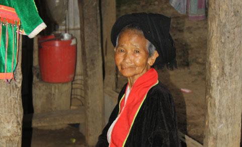
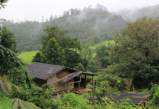
Complex mountain ranges and a mild climate characterise an area with moist and dense summit forest which is the source of important tributaries of the Mae Ping River, one of northern Thailand's major waterways. Various streams descend, forming beautiful waterfalls throughout the park. These include the Siriphum, Vajirathan, Mae Pan, Mae Klang and, the largest of all, Mae Ya Waterfall. Meo and Karen hilltribes inhabit the park.
Visiting is possible throughout the year. The best period for viewing waterfalls is May through November. The best period for viewing wild flowers is December through February. The best period for ornithologists is November through March.
Tourist Attractions
Brichinda Cave
This impressive limestone cave has a gigantic entrance camber and tower and a scene huge chamber with a skylight opening to the surface. This cave has a medium-size, which has beautiful stalagmite, is situated in the middle of deciduous forest. It takes about one hour walk from the main road.
Mae Klang Waterfall
Mae Klang Waterfall is located in the east of the National Park, approximately 8 kilometers away from Chom Thong - Doi Inthanon Road, then make a left hand turn for 1 kilometer until reaching the Waterfall. This waterfall is very popular among Thai and foreigners who come to swim, picnic and relax. The rapid stream and waterfall spill over the area produce cool and pleasant for visitors.
Mae Pang Waterfall Group
Mae Pan Waterfall at Km. 6.6 on the Mae Chaem road is the turn-off to Mae Pan Waterfall. The laterite access road descends about two kilometers to the Mae Chaem Ranger Station and campground, and is suitable for any vehicle although the road can be slippery on the uphill after a heavy rain. The area is quiet, of the beaten track, and can be described as the backcountry of Doi Inthanon Park. It offers a rewarding loop hike of 1 to 2 hours through untouched terrain with small waterfalls and tumbling creeks along most of the route. You can walk along the whole loop since it is largely unmarked, but any visitor can walk the 800 meters to Mae Pan Falls and back again, as wall as the 200 meters to Huay Sai Luaeng Falls (just beyond the campground).
Mae Ya Waterfall
Mae Ya Waterfall is a large waterfall of 260 meters high, located in the south of the National Park. The Waterfall originated in Mae Ya Gully. Many tourists claimed that the Waterfall is one of the most beautiful waterfalls in Thailand since the Waterfall is like a combination of different waterfalls. The Waterfall can be accessed from the right hand side of Chomthong-Hod Road, then, follow the guide posts.
Siriphum Waterfall
The Waterfall was formerly called “Lao Lee Waterfall”, which was named after the headman of a nearby tribesman village. After that Mr.Ror.Vor. Jakthong Thongyai, a former Minister of Agriculture and Cooperatives, named the Waterfall “Siriphum” to enhance the prestige of His Majesty the King and Her Majesty the Queen. The Waterfall is located near km 31, Chomthong-Doi Inthanon Raod.
Siritan Waterfall
This waterfall is 81 km. from Chiang Mai. Take the route 108, Chiang Mai - Hod and turn left at 58 th km. and continue on Chomg Tong - Doi Intanon for 23 km. you will reach Siritan Waterfall. The 100 meters trail in the Montain Rainforest will brighten up your day.
Summit of Doi Inthanon
Summit of Doi Inthanon offers fine views to visitors, especially during November and December. On the summit, there is a stupa containing the body of prince Intharawichayonon, whose chronicle placed on the back of the marble plaque nearby. However photographing any parts of the radar station s forbidden.
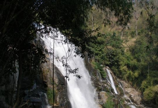
Vachiratharn Waterfall
Vachiratharn Waterfall (or “Muangyong Waterfall”) is a 70-meter-high waterfall, having originated in Mae Klang Gully and being located near km 22, Chomthong-Doi Inthanon Raod. At the Waterfall, there are many caves; and the most beautiful one is Borijinda Cave, a large cave with stalactite and stalagmite, located in the east of the National Park.
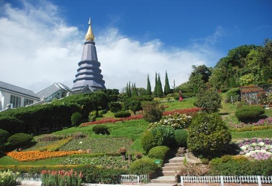
View Point and Phra Mahathat Chedi
At Km. 41 of Chomthong-Doi Inthanon Road, there are Phra Mahathat Chedi Nophamethanidol and Phra Mahathat Noppholbhumisiri built for presenting to His Majesty the King and Her Majesty Queen Sirikit by Thai Air Force.
Wang Kwai Waterfall
This waterfall has cold pleasant water which is suitable for swimming. Visitors can take route 00, Chiang Mai - Hod, turn right to route 00, Chom Tong - Doi Inthanon at 58 km. and proceed for another 9.7 km.
Napamaytanidol Chedi and Phra Mahatat Napaphon Bhumisiri
Napamaytanidol Chedi and Phra Mahatat Napaphon Bhumisiri (km. 41.8) Continuing north on the main summit road, turn left at km. 41.8 over a bridge on a paved road which leads to a magnificent chedi to honour the 60th birthday of King Bhumipol and Queen Sirikit.
Brichinda Cave Nature Trail
The hiking to discover the natural forest is one of the most interesting activities and this gives visitors a chance to touch the nature closely.
Kaew Mae Pang Nature Trail
Kaew Mae Pan Nature Trail one of the most beautiful and rewarding walks in the park is a new trail, which begins a short distance up the main summit road from Napamaytanidol. The path leads for a kilometer or more through dense, moist evergreen forest, then emerges and follows the top of a steep slope bordering the canyoned headwaters of the Mae Pan river. Dotted with red rhododendron, the trail proceeds southward for another kilometer with fine, open views to the west, then re-enters the forest and eventually terminates at Napamaytanidol Chedi. Two hours would allow a leisurely walk with camera stops.
Tours:
TTAC02 - Doi Inthanon National Park Adventure Tour - rainy season
TTAC02 - Doi Inthanon National Park Adventure Tour - dry season
TTTK20 - Doi Inthanon National Park Experience Tour – 2 days
Selected Videos